 Tropical storm Emily is a long, long way away from Coastal Georgia, and the current forecast has it remaining a tropical storm (not a hurricane) as it gets closer to us. [Update, 8/4: Emily collapsed earlier today over the mountains of Hispaniola.]
Earlier today, the projected track had the storm hugging the east coast of Florida and potentially coming ashore along the Georgia coast, but the track as I write this shows the storm peeling off to sea a little earlier than that.

Emily's track as of 8/3/11 at 5 p.m. on the National Hurricane Center website
In my 16 years in Savannah, hurricanes and tropical storms in the Atlantic have followed the same general trend — they move to the north and east as they get closer to our seemingly protected spot. Or they take a turn west and cut across the northern portion of Florida.
But it hasn’t always been that way. From NOAA Revisits Historic Hurricanes:
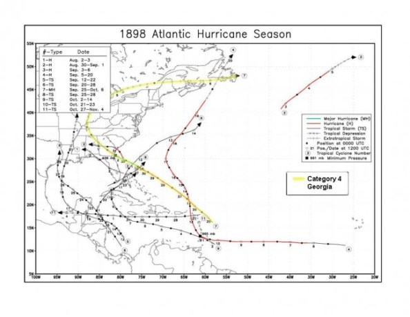
During the 20th Century, Georgia did not have even a single major hurricane make a landfall along its coast. However, such absence did not continue back to the 19th Century. In contrast, Georgia experienced three major hurricanes in the later half of the 19th Century: a Category 3 in 1854 near Savannah, the Category 3 “Sea Islands Hurricane” in 1893 that killed 1000-2000 people near Savannah and a Category 4 in 1898 near Brunswick. Knowledge that such strong hurricanes have impacted this portion of the coast (and will undoubtedly hit again) is important for residents of Georgia to plan for the future.
And, from that same site, here are the tracks of those three hurricanes.
First the 1854 Category 3 storm:

The deadly Sea Islands Hurricane of 1893:

The 1898 Category 4 hurricane:

The Georgia coast could go another century without a major hurricane making landfall. But I think that would be a surprise.
